When a story breaks, geography becomes part of the headline. Where it happened, how it spread, what areas are affected, and what comes next. Yet turning that context into clear on-air storytelling often takes too long, relies on fragmented tools, or forces teams to compromise between speed, visual consistency, and operational reliability.
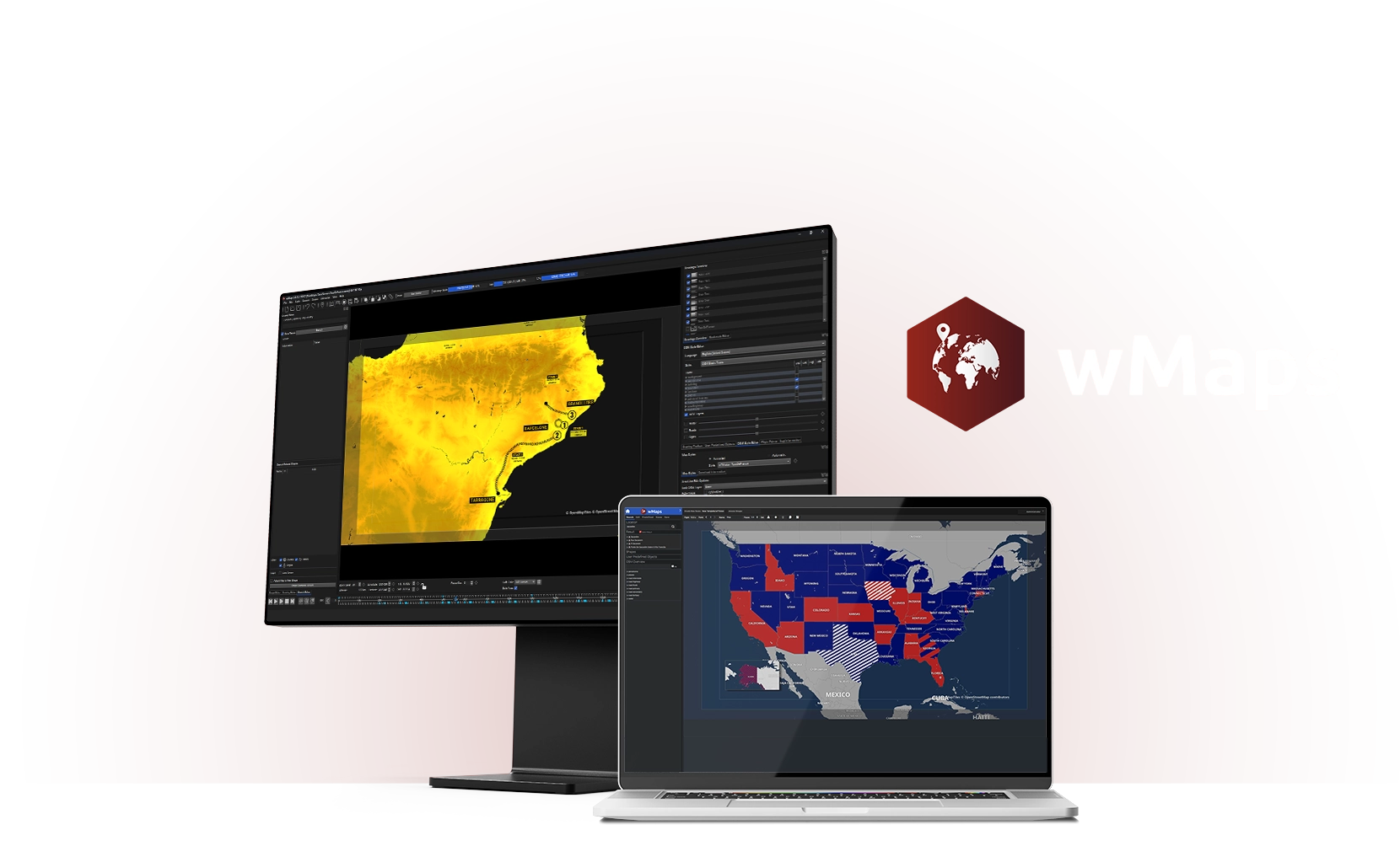
wTVision is closing that gap with wMaps, a broadcast-grade mapping platform designed to help newsroom and live production teams bring location-based narratives to air with clarity and pace. The solution includes two modules built for distinct user personas and operational roles within the workflow: wMaps Standalone for creative teams producing high-end map animations and pre-rendered outputs, and wMaps Client/Server, a browser-based newsroom workspace for collaborative map production and rundown-driven execution.
Designed for the people behind the story
Some maps are built like crafted sequences, where designers shape perspective, motion, and visual language. Others are newsroom-driven, where editorial teams need fast updates that keep pace with live coverage. wMaps was built to support both realities.
The Standalone module enables creative teams to design and animate 2D and 3D maps through an advanced professional Graphical User Interface (GUI) created for high-end map animation and storytelling. Using keyframes, symbols, satellite imagery, and OpenStreetMap-based visuals, teams can deliver pre-rendered outputs that fit naturally into MAM-led distribution and playout routines.
In parallel, Client/Server brings mapping directly into the daily newsroom rhythm. Through a browser-based interface, up to 10 concurrent users per server can create and manage maps simultaneously, supporting rundown-driven triggering and automated playout. The goal is simple: make mapping part of the editorial cadence, not a last-minute production request.
“In our work with media enterprises, we consistently see the same gap: maps are crucial to storytelling, yet they’re not embedded in the workflow,” said Alex Roriz, VP Global Partnerships, Business Strategy & Growth at wTVision. “wMaps brings mapping directly into the production chain, completing our end-to-end Graphics & Media offering and enabling newsroom and editorial teams to deliver location-driven stories with broadcast-grade consistency and operational confidence.”
A mapping language that holds up under pressure
By aligning creative production and newsroom operations under a single product, wMaps helps teams build a consistent mapping language that can be reused across breaking news, explainers, election coverage, severe weather tracking, sports storytelling, and other location-driven scenarios, without reworking the same elements under pressure.
“In today’s broadcast environment, speed and operational efficiency are fundamental,” said Flávio Maurício, CTO at wTVision. “wMaps is a workflow-native mapping platform, fully embedded in production operations, not a standalone graphics silo. It combines real-time localization, dynamic animation, and scalable performance to support modern newsroom media and graphics workflow execution.”
Built to fit your on-air ecosystem
wMaps becomes part of wTVision’s broader on-air graphics and media ecosystem, providing a clear operational path from map creation to playout. The result is a mapping layer that supports daily newsroom routines while preserving the visual quality viewers expect from broadcast storytelling.
wTVision will showcase wMaps through live demonstrations at NAB Show 2026 in Las Vegas (April 19–22, North Hall, Booth N1223). Visitors can register using Guest Pass Code NS6959. To request a demo or learn more about wMaps, contact wTVision at marketing@wtvision.com.